MinnesotaSeasons.com distribution maps for plants have been updated to include location data from Early Detection and Distribution Mapping System (EDDMapS).
“EDDMapS is a web-based mapping system for documenting invasive species distribution… EDDMapS combines data from other databases and organizations as well as volunteer observations to create a national network of invasive species distribution data.”
EDDMapS lists 394 species in Minnesota. Not all the listed plants are a problem in Minnesota, but all of them are exotic to the U.S. and are listed as a problem somewhere in the U.S. Distribution maps for listed plants that appear on MinnesotaSeasons,com now include EDDSMapS observations.
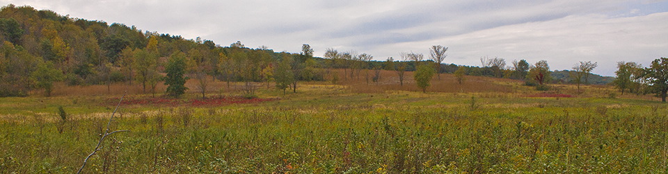
Russian olive
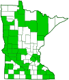
I’m not sure there is much value in EDDMaps for most people. Little of the information has been vetted by anyone one and is often erroneous. Check out the distributions for giant hogweed – Heracleum mantegazzianum and multiflora rose – R. multiflora.
No and no – likely the result of poorly qualified field staff reporting these observations – my guess is of cow parsnip and a Rubus spp of some sort – respectively. So don’t look to these maps as accurate distributions for anything at this time.
I agree that EDDMaps data lacks the accuracy of herbarium collections. BONAP has been criticized for the same reason. However, for most species, distribution maps generated from herbarium data only will not necessarily be more accurate than maps that include data from these other sources.
EDDMaps and BONAP data undoubtedly include plants that have been misidentified. On the other hand, the Bell herbarium has not collected every species that occurs at any one site or in any one county. Herbarium listings must be seen as the most accurate but definitely incomplete.
Compare the maps of red mulberry on the Minnesota Plants page on MinnesotaSeasons.com. The USDA map shows the species in only two counties. Bell Herbarium has historical records from Houston County but no current records in the state. Red mulberry has been planted as a fruit/ornamental tree in Minnesota. It can be found not only in yards but also in parks and near former homesteads that are now public places. Occurrences at parks and public places are not usually considered if the species was planted there and is not naturalized. The species may survive and produce new plants on the site but not spread. It essentially becomes a permanent but locally occurring species at that site.
The criterion for inclusion at MinnesotaSeasons.com, as stated on the Home page, is “Native, naturalized, invasive, or simply planted—any plant growing outside of cultivation in Minnesota.”
Mr. John Valo:
I recently read your Feb. 20, 2014 where you mention BONAP’s data. Perhaps you and others should have a few facts in your possession prior to making such assertions. Of the 6,000,000 county-level occurrences displayed in our website, more than 95% are backed by vouchers. Indeed, vouchers serve as the basis for our entire database. Your assumption to the contrary is incorrect and baseless. Perhaps you should know that we maintain a database of over 50,000,000 vouchers, from which we have condensed and displayed the 6,000,000 occurrences that you see on our website. I can’t speak for EDDMapS, but I would suggest that you check your facts prior to posting more unwitting assertions.
Dr. John T. Kartesz
BONAP
http://www.bonap.org/
Dr. Kartesz;
I have looked at the list of sources for distribution data at BONAP. The list of contributors includes reputable institutions, field botanists, taxonomic group specialists, U.S government sources, and State government sources. That is why BONAP data is included in almost all of the plant distribution maps at MinnesotaSeasons.com.
You must be referring to the statement “EDDMaps and BONAP data undoubtedly include plants that have been misidentified.”
This conclusion was based on correspondence with the Minnesota Department of Natural Resources federal endangered plant coordinator regarding the distribution of Platanthera praeclara and other federally listed plant species in Minnesota. On reviewing that correspondence and the information you provided I see that the statement must be corrected. Errors in the BONAP species distribution data should not be attributed to misidentification.
The botanist at the Minnesota DNR mentioned above suggests that “The historical collections for Platanthera include some dubious locations that may be where old specimens were processed rather than collected but there was never any putative collection from any county bordering the St. Croix River.”
Thanks.
John F. Valo
MinnesotaSeasons.com
Mr. John Valo:
Thank you for your clarification. Certainly, when old species circumscriptions are modified as was necessary to produce Platanthera praeclara, hundreds of specimens need to be reassessed to determine the precise distributions of both the old and new species concepts. To the degree possible, we monitor these changes and attempt to match the newly defined phytogeographies with the newly defined circumscriptions. However, when assessing the vascular flora of a continent the size of North America, this is not an easy task. Please note that we will be releasing the 2014 edition of our website this fall. I would suggest that you and others view the many thousands of changes that we will have included there.
Dr. John T. Kartesz
BONAP
http://www.bonap.org/